

Preview
Document Type
StillImage
Contributing Institution
Maine State Archives
Identifier
208462
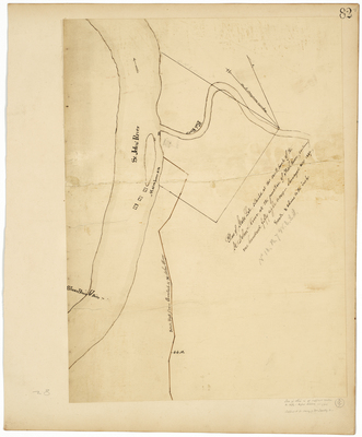
Description
Survey of state lots at the south bank of the St. John River at junction of Fish River on a scale of 8 chains to one inch. Noted in pencil "No. 18, R7 WELS"
Exact Creation Date
1839
Language
English
Location
Aroostook County; Fort Kent
Keywords
Cartography; Maps; Maine Land Office; Planbooks; Surveys
Image Location
Rights Statement
No Copyright - United States. URI: http://rightsstatements.org/vocab/NoC-US/1.0/
The organization that has made the Item available believes that the Item is in the Public Domain under the laws of the United States, but a determination was not made as to its copyright status under the copyright laws of other countries. The Item may not be in the Public Domain under the laws of other countries. Please refer to the organization that has made the Item available for more information.