

Preview
Document Type
StillImage
Contributing Institution
Maine State Archives
Identifier
210848
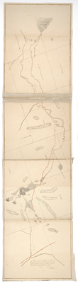
Description
Plan of a road from the northwest bay of Moosehead Lake to the Canadian border. Scale of 40 chains to an inch.
Exact Creation Date
1836
Language
English
Other Location
Canada Road; Portage Stream; River de Loup; Penobscot River; Plymouth Grant; Middlesex Canal Grant
Keywords
Cartography; Maps; Maine Land Office; Planbooks; Surveys
Image Location
Rights Statement
No Copyright - United States. URI: http://rightsstatements.org/vocab/NoC-US/1.0/
The organization that has made the Item available believes that the Item is in the Public Domain under the laws of the United States, but a determination was not made as to its copyright status under the copyright laws of other countries. The Item may not be in the Public Domain under the laws of other countries. Please refer to the organization that has made the Item available for more information.