

Preview
Document Type
StillImage
Contributing Institution
Maine State Archives
Identifier
208136
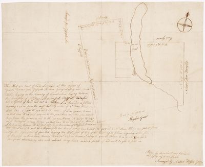
Description
Survey of land for Jonas Stevens Jr., Joseph Stevens, George Lasley and Amos Hobbs, between Township Four, Shepardsfield, Otisfield, Waterford, and a grant of land laid out to Arthur Lee. Scale of 150 rods to one inch.
Exact Creation Date
1792
Language
English
Location
Oxford County; Otisfield; Waterford
Other Location
Shepards Grant
Keywords
Cartography; Maps; Maine Land Office; Planbooks; Surveys
Image Location
Rights Statement
No Copyright - United States. URI: http://rightsstatements.org/vocab/NoC-US/1.0/
The organization that has made the Item available believes that the Item is in the Public Domain under the laws of the United States, but a determination was not made as to its copyright status under the copyright laws of other countries. The Item may not be in the Public Domain under the laws of other countries. Please refer to the organization that has made the Item available for more information.