

Preview
Contributing Institution
Maine State Archives
Document Type
StillImage
Identifier
208423
Description
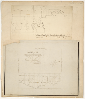
A plan of the South half of Township No. 1 "Titcomb's Survey" Belonging to the 2nd Range of Townships North of Bingham's Penobscot Purchase as run into lots in Sept. 1832. Now called Lambert Lake in Washington County.
A Plan of the Survey of Lots on Fish River Road so called in Township No. 17 Range 7 surveyed in the months of May and June A.D. 1847. Now called Wallagrass in Aroostook County.
Language
English
Location
Aroostook County; Wallagrass; Washington County; Lambert Lake Twp
Keywords
Cartography; Maps; Maine Land Office; Planbooks; Surveys
Image Location
Rights Statement
No Copyright - United States. URI: http://rightsstatements.org/vocab/NoC-US/1.0/
The organization that has made the Item available believes that the Item is in the Public Domain under the laws of the United States, but a determination was not made as to its copyright status under the copyright laws of other countries. The Item may not be in the Public Domain under the laws of other countries. Please refer to the organization that has made the Item available for more information.