


Files
Download Map (1.1 MB)
Document Type
StillImage
Description
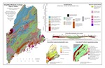
Maine Geological Survey, Open-File Map SBGMM. Map showing the simplified bedrock geology of Maine. Inset maps show regional metamorphic zones and generalized Northern Appalachian geology. The map also includes a generalized geologic cross section. A table and text on the reverse describe the geologic history of Maine and how it relates to plate tectonics.
Publication Code
SBGMM
Publication Date
1-1-2002
Publisher
Maine Geological Survey
Location
Androscoggin County; Aroostook County; Cumberland County; Franklin County; Hancock County; Kennebec County; Knox County; Lincoln County; Oxford County; Penobscot County; Piscataquis County; Sagadahoc County; Somerset County; Waldo County; Washington County; York County
Map Type
Bedrock Geology Maps (regional); Geologic Maps of the State of Maine
Map Scale
1:2000000
Recommended Citation
Loiselle, Marc (cartographer), 2002, Simplified bedrock geologic map of Maine: Maine Geological Survey, Open-File Map SBGMM, 11" x 17" color map, scale 1:2,000,000. Maine Geological Survey Maps. 24. http://digitalmaine.com/mgs_maps/24
Rights Statement

No Copyright - United States. URI: http://rightsstatements.org/vocab/NoC-US/1.0/
The organization that has made the Item available believes that the Item is in the Public Domain under the laws of the United States, but a determination was not made as to its copyright status under the copyright laws of other countries. The Item may not be in the Public Domain under the laws of other countries. Please refer to the organization that has made the Item available for more information.