

Preview
Document Type
StillImage
Contributing Institution
Maine State Archives
Identifier
206947
Description
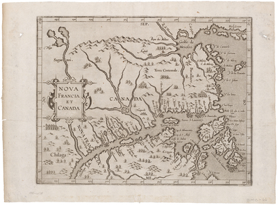
This map is the first appearance of the name "Canada" on a printed map and the first map to focus on the St. Lawrence River and Gulf of St. Lawrence.
The map depicts Canada from just below Montreal (Iroquois settlement of Hochelaga) on the St. Lawrence, depicting the known regions of Canada at the end of the 16th Century. Prince Edward Island appears as the “Y. de S. Johan” and Newfoundland is shown as an archipelago with its Portuguese name, “Terra de Bacallaos” or “Land of Cod.”
Broad Creation Date
1597
Dimensions
11" x 9.5"
Language
French
Keywords
Cartography; Maps; Canada