

Preview
Document Type
StillImage
Contributing Institution
Maine State Archives
Description
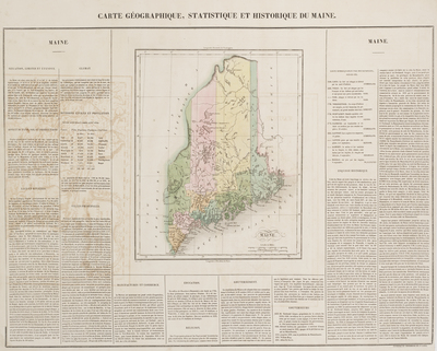
Early map of Maine, hand colored by counties. Roads, towns, rivers, and lakes are included on map. Key notes flags for 10 remarkable battles. Text surrounds map, which includes details concerning the topography, indigenous lands, rivers, climate, towns, manufacturing, commerce, education, history, population by county, and other information.
Buchon follows the format of Carey & Lea's Atlas. The atlas was issued in six editions in English, French & German between 1822 and 1827.
Broad Creation Date
circa 1822
Language
French
Other Location
Maine
Keywords
Cartography; Maps