

Preview
Document Type
StillImage
Contributing Institution
Maine State Archives
Identifier
206942
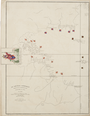
Description
This 1834 atlas was issued as part of Humboldt and Bonpland’s Voyage aux régions équinoxiales du Nouveau Continent fait en 1799, 1800, 1801, 1802, 1803 et 1804 (Paris, 1808-1834), which was published in over thirty volumes over several decades. Included in the atlas is this first printing of a manuscript map made by Spanish conquistador, cartographer, and explorer Juan de la Cosa (ca. 1460-1509), who sailed with the first three voyages of Columbus and was the owner of the Santa María.
This chart (XXXIII) incorporates lands discovered in America up to 1500 during expeditions by Spanish, Portuguese, and English expeditions to America. Juan de la Cosa’s mappa mundi is believed to be the earliest extant map showing any part of the continent of North America.
Broad Creation Date
1500 and 1834
Dimensions
16" x 19"
Language
French; Spanish
Other Location
Cuba; Equator; Azores; North America; Caribbean
Keywords
Cartography; Maps