

Preview
Document Type
StillImage
Contributing Institution
Maine State Archives
Identifier
BMC-3 p.13
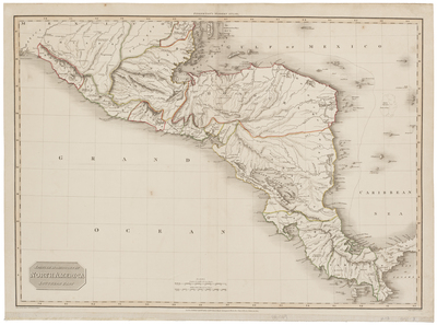
Description
A map of the southern part of North America, now known as Central America. This map was published in Pinkerton’s Modern Atlas in September 1811. The map depicts landforms from Oaxaca to Panama and includes the Gulf of Mexico, Caribbean Sea and the Grand Ocean (Pacific Ocean).
Spanish dominions in North America, sourthern part. Drawn under the direction of Mr. Pinkerton by L. Hebert. Neele sculpt. 352 Strand. London: published September 11, 1811, by Cadell & Davies, Strand & Longman, Hurst, Rees, Orme, & Brown, Paternoster Row.
Exact Creation Date
9-11-1811
Dimensions
21.5" x 29"
Language
English
Other Location
Mexico; Central America
Keywords
Cartography; Maps