

Preview
Document Type
StillImage
Contributing Institution
Maine State Archives
Identifier
206849
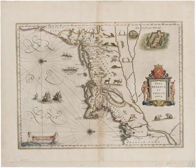
Description
This elaborately decorated map is based on the 1614 explorations of Adrian Block, a fur trader working for the Dutch, who sailed from the north shore of Long Island to explore the southern coast of New England. Willem Blaeu, the premier Dutch map and globe maker of that period, published this map of New York and New England based largely on Block's reports.
Oriented with west at the top and the north at the right, it is the first printed map to depict details of the interior of New England. It shows New England south to Cape Henry, Virginia. Includes decorative cartouche and North American motifs, including Native Americans and their villages and canoes, as well as bears, beavers, turkeys, and other fauna.
Broad Creation Date
circa 1635
Dimensions
20"x 23"
Language
Latin
Other Location
Virginia; New England; New Netherland
Keywords
Cartography; Maps